
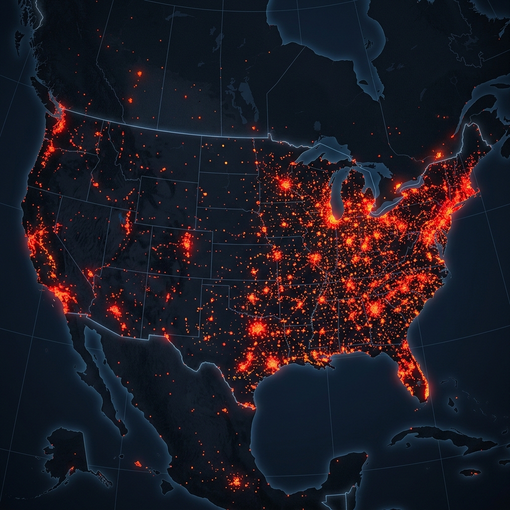
Fin 2024, une visualisation de données publiée sur r/MapPorn montrait 110 000 caméras Flock Safety réparties à travers les États-Unis. Le post est devenu viral, générant des dizaines de milliers de votes positifs et de commentaires. Pour la plupart des personnes qui l'ont vu, c'était la première fois qu'elles comprenaient l'ampleur réelle du déploiement des caméras de lecture automatique de plaques d'immatriculation (LAPI) dans les communautés américaines. Cet article explique ce que montre la carte, d'où proviennent les données sous-jacentes et comment vous pouvez vérifier la couverture des caméras dans votre région.
Qu'a montré la carte Flock de 110 000 caméras ?
Le post Reddit cartographiait les emplacements confirmés des caméras Flock Safety à travers les États-Unis en utilisant des données agrégées à partir de documents publics, de demandes FOIA et de signalements communautaires participatifs. La carte résultante montrait des grappes de caméras concentrées dans :
- Quartiers suburbains — en particulier les communautés gérées par des associations de propriétaires où Flock vend directement aux associations de propriétaires plutôt qu'aux seuls services de police
- Périmètres des districts scolaires — de nombreux districts scolaires ont contracté Flock pour la surveillance des entrées de campus
- Grands axes routiers et bretelles d'entrée/sortie d'autoroute — où les forces de l'ordre ont placé des caméras pour capturer un volume élevé de véhicules
- Zones commerciales et centres commerciaux — les districts d'amélioration commerciale qui ont souscrit au service
La carte a suscité de nombreuses discussions car de nombreux spectateurs ont réalisé qu'ils vivaient à portée de plusieurs caméras qu'ils n'avaient jamais remarquées — et que les mouvements de leur véhicule à l'entrée et à la sortie de leur quartier étaient enregistrés et stockés.
D'où proviennent les données de localisation des caméras Flock ?
Flock Safety ne publie pas de carte publique officielle des emplacements de caméras. Les données utilisées dans les cartes communautaires proviennent de plusieurs sources :
- Demandes FOIA: Les demandes de documents publics adressées aux forces de l'ordre révèlent les emplacements des caméras, les détails des contrats et les politiques de conservation des données. Des journalistes et des défenseurs de la vie privée ont déposé des centaines de ces demandes dans les États américains.
- Avis de HOA et de la communauté: Les associations de propriétaires qui installent des caméras Flock annoncent fréquemment leur déploiement dans les bulletins d'information communautaires, les procès-verbaux de réunions ou les publications sur leur site web — qui sont indexés par les moteurs de recherche.
- Signalements participatifs: Des projets comme la base de données « Street Level Surveillance » de l'Electronic Frontier Foundation recueillent les signalements de caméras ALPR soumis par la communauté. Toute personne qui identifie et photographie une caméra peut soumettre sa localisation.
- Cartographie commerciale: Certains chercheurs ont utilisé l'analyse d'images satellite et au niveau de la rue pour identifier à grande échelle le boîtier distinctif des caméras Flock.
Existe-t-il une carte officielle des caméras Flock que je peux consulter ?
Non. Flock Safety ne fournit pas de carte publique des emplacements des caméras. La position de l'entreprise est que la publication des emplacements exacts des caméras réduirait leur effet dissuasif et pourrait aider les voleurs de véhicules à contourner les zones couvertes.
Pour trouver des caméras dans votre région, les ressources non officielles les plus fiables sont :
- EFF Atlas of Surveillance (atlasofsurveillance.org): Une base de données consultable des technologies de surveillance déployées par les forces de l'ordre à travers les États-Unis, y compris les systèmes ALPR. Consultable par ville et par État.
- Ordres du jour et procès-verbaux des réunions des collectivités locales: La plupart des villes et comtés américains publient leurs ordres du jour de réunion en ligne. Rechercher « [votre ville] Flock Safety » dans une recherche de documents gouvernementaux révèle souvent les approbations de contrats et les données sur le nombre de caméras.
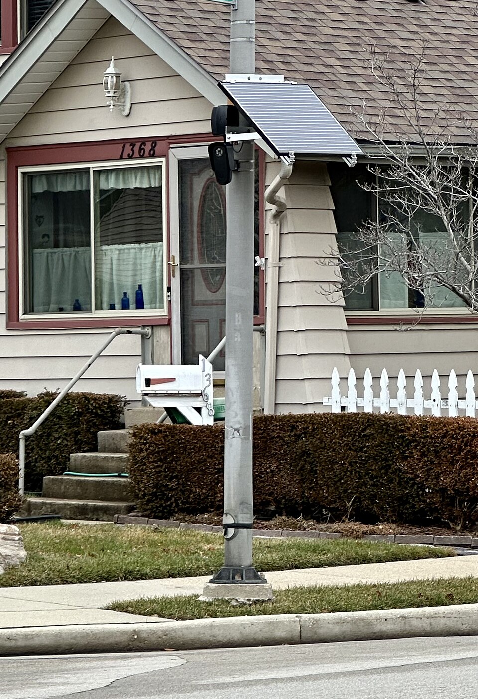
- Identification physique: Les caméras Flock Safety se présentent sous la forme d'un boîtier rectangulaire blanc distinctif, généralement de 20 à 30 cm de hauteur, monté sur des poteaux au niveau de la route. Un panneau solaire est souvent visible. Une fois que vous savez quoi chercher, elles sont identifiables à vue dans la plupart des quartiers qui en sont équipés.
Combien y a-t-il de caméras Flock et à quelle vitesse le réseau se développe-t-il ?
En 2025, Flock Safety a déclaré publiquement que son réseau compte plus de 5 000 agences d'application de la loi clientes à travers les États-Unis. Le nombre total de caméras, y compris les abonnés privés (associations de propriétaires, écoles, entreprises), a été estimé dans des analyses indépendantes à plus de 150 000 unités, contre environ 110 000 indiquées dans la carte virale de 2024.
Le réseau connaît une croissance rapide pour plusieurs raisons :
- Flock’s subscription model has a low entry price relative to installing a full CCTV system — a single camera costs approximately $2,500–$3,500 per year
- De nombreux États américains ont adopté des lois autorisant ou encourageant le déploiement de la LAPI pour la récupération de véhicules et les enquêtes criminelles
- Les HOA et les communautés privées peuvent s'abonner sans impliquer les forces de l'ordre, créant ainsi un réseau privé parallèle qui partage des données avec la police par accord
- La conservation des données de 30 jours par défaut permet aux agences de soutenir que le système protège la vie privée tout en fournissant des données d'enquête utiles
Que signifie la couverture des caméras Flock pour votre vie privée ?
Si vous vivez dans un quartier américain desservi par des caméras Flock — ce qui, selon la carte virale, concerne une proportion substantielle de l'Amérique suburbaine — les déplacements de votre véhicule sont enregistrés chaque fois que vous entrez ou sortez de la zone. Ces données sont conservées 30 jours par défaut et sont consultables par les agences abonnées.
Cela ne signifie pas que vous faites l'objet d'une surveillance active. Les données Flock sont passives — elles sont stockées et consultables, mais aucun analyste ne surveille vos déplacements en temps réel. La préoccupation en matière de vie privée réside dans le potentiel d'enquête rétrospective : si quelque chose se produit dans votre quartier, les enquêteurs peuvent vérifier qui se trouvait dans la zone et quand, sans qu'aucun soupçon préalable ne soit nécessaire pour lancer la requête.
L'ACLU et l'EFF soutiennent que cela constitue une forme de surveillance de masse qui normalise le suivi de civils innocents. Flock Safety affirme qu'il s'agit d'un outil objectif et efficace qui élimine les biais humains de la surveillance des véhicules et a directement contribué à résoudre des milliers de crimes graves.
FAQ
Puis-je trouver une carte des caméras Flock en ligne ?
Il n'existe pas de carte publique officielle des caméras Flock Safety. La ressource non officielle la plus complète est l'Atlas of Surveillance de l'EFF sur atlasofsurveillance.org, qui couvre les technologies ALPR et autres technologies de surveillance dans les juridictions américaines. Le post r/MapPorn devenu viral en 2024 était une visualisation ponctuelle basée sur des données agrégées de registres publics ; aucune version mise à jour en direct de cette carte spécifique n'est maintenue publiquement.
Puis-je refuser d'être enregistré par les caméras Flock ?
Aucun mécanisme de désinscription n'existe pour l'enregistrement sur les routes publiques aux États-Unis. Tout véhicule visible depuis une route publique peut être photographié par une caméra ALPR en bord de route. Le seul recours est législatif — plusieurs États américains ont adopté ou envisagent des projets de loi limitant les durées de conservation des données ALPR, restreignant les agences pouvant accéder aux données et exigeant des rapports de transparence annuels de la part des agences utilisant cette technologie.
Les caméras Flock existent-elles en dehors des États-Unis ?
Flock Safety opère principalement aux États-Unis. Le Royaume-Uni et l'UE disposent de leur propre infrastructure ANPR (reconnaissance automatique des plaques d'immatriculation) exploitée par les forces de police dans le cadre de réglementations différentes. Le réseau ANPR britannique est géré par le National Police Chiefs' Council et régi par la loi Protection of Freedoms Act 2012, avec des règles de conservation des données plus strictes que de nombreux déploiements Flock aux États-Unis.
Pour plus de contexte sur la technologie de surveillance ALPR, les implications pour la vie privée et la différence entre les réseaux de surveillance publics et les équipements de sécurité personnels, consultez notre guide complet des caméras Flock Safety. Pour les caméras de sécurité personnelles qui gardent les enregistrements sous votre propre contrôle, visitez la Gamme QZT Security.

 English
  Italiano
  Deutsch
  Français
  Español
  Polski